


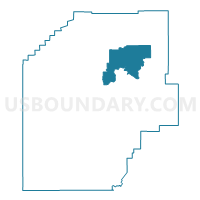
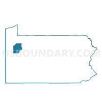
CORNPLANTER TWP DIST 02, Venango County, Pennsylvania
About
Outline

Summary
| Unique Area Identifier | 664066 |
| Name | CORNPLANTER TWP DIST 02 |
| County | Venango County |
| State | Pennsylvania |
| Area (square miles) | 31.55 |
| Land Area (square miles) | 31.28 |
| Water Area (square miles) | 0.27 |
| % of Land Area | 99.15 |
| % of Water Area | 0.85 |
| Latitude of the Internal Point | 41.50097580 |
| Longtitude of the Internal Point | -79.66275680 |
Maps

Graphs
Select a template below for downloading or customizing gragh for CORNPLANTER TWP DIST 02, Venango County, Pennsylvania


Neighbors
Neighoring Voting District (by Name) Neighboring Voting District on the Map
- ALLEGHENY TWP Voting District, Venango County, PA
- CHERRYTREE TWP Voting District, Venango County, PA
- CORNPLANTER TWP DIST 01, Venango County, PA
- OAKLAND TWP Voting District, Venango County, PA
- OIL CITY DIST 03, Venango County, PA
- OIL CREEK TWP Voting District, Venango County, PA
- PRESIDENT TWP Voting District, Venango County, PA
- ROUSEVILLE Voting District, Venango County, PA
- SUGAR CREEK VTD 02, Venango County, PA
Top 10 Neighboring County Subdivision (by Population) Neighboring County Subdivision on the Map
- Oil City city, Venango County, PA (10,557)
- Sugarcreek borough, Venango County, PA (5,294)
- Cornplanter township, Venango County, PA (2,418)
- Cherrytree township, Venango County, PA (1,540)
- Oakland township, Venango County, PA (1,504)
- Oil Creek township, Venango County, PA (854)
- President township, Venango County, PA (540)
- Rouseville borough, Venango County, PA (523)
- Allegheny township, Venango County, PA (276)
Top 10 Neighboring Place (by Population) Neighboring Place on the Map
Top 10 Neighboring Unified School District (by Population) Neighboring Unified School District on the Map
- Oil City Area School District, PA (15,053)
- Titusville Area School District, PA (14,151)
- Forest Area School District, PA (8,287)
- Valley Grove School District, PA (6,901)
Top 10 Neighboring State Legislative District Lower Chamber (by Population) Neighboring State Legislative District Lower Chamber on the Map
Top 10 Neighboring State Legislative District Upper Chamber (by Population) Neighboring State Legislative District Upper Chamber on the Map
Top 10 Neighboring 111th Congressional District (by Population) Neighboring 111th Congressional District on the Map
Top 10 Neighboring Census Tract (by Population) Neighboring Census Tract on the Map
- Census Tract 2006, Venango County, PA (5,294)
- Census Tract 2011, Venango County, PA (4,835)
- Census Tract 2001, Venango County, PA (4,167)
- Census Tract 2000, Venango County, PA (3,562)
- Census Tract 2007, Venango County, PA (2,201)